Goals

By using this guide, students will be able to:

  • Differentiate the varying types of information that maps can provide.
  • Discuss the intersection of history and geography.
  • Identify important locations for early Texas history, the Texas Revolution, the Republic era, and annexation into the United States in 1845.
  • Describe the historical events that created the modern-day Texas border.

Map No.1: Native Americans in Texas, 1763-1821

Map of Native Americans in Texas, 1763-1821.

Texas Essential Knowledge and Skills
4th Grade TEKS: 4.1B, C & D; 4.6B; 4.8A & C; 4.10A; 4.21B & C; 4.22
7th Grade TEKS: 7.1A; 7.2A; 7.8; 7.9; 7.21; 7.22, 7.23 

Map introduction
The image of Native Americans is often based on what we see in movies or read in fictional accounts about the early settlement of the nation. The typical representation of a Native American has been a warrior armed with bow and arrow, mounted on horseback in front of a teepee, preparing to ride off to hunt buffalo. While it is true that this image fits some Native Americans who lived on the plains during the eighteenth and nineteenth centuries, it does not accurately depict all Native American groups by any means. Native American culture was as varied as the different number of tribes. These differences were often based on environmental factors. 


Map No.2: Missions and Presidios in Texas

Map of missions and presidios in Texas.

Texas Essential Knowledge and Skills
4th Grade TEKS: 4.2A, B, & C; 4.6B; 4.8A & B; 4.21B & C; 4.22
7th Grade TEKS: 7.1A; 7.2B, C & F; 7.8; 7.9; 7.11A & B; 7.19B & C; 7.21; 7.22, 7.23  

Map introduction
A mission was an institution designed to civilize frontier regions. Spanish officials established missions throughout South America, Central America, and North America. In theory, the line of missions was supposed to advance every few years as indigenous people were converted into Spanish subjects. In many areas, however, the mission line became fixed as missionaries encountered harsh terrain and fierce nomadic tribes. 

Map No.3: Early San Antonio, c.1800

Map of early San Antonio, c.1800.

Texas Essential Knowledge and Skills
4th Grade TEKS: 4.2A, B, & C; 4.6B; 4.8A & B; 4.21B & C; 4.22
7th Grade TEKS: 7.1A; 7.2B, C & F; 7.8; 7.9; 7.11A & B; 7.19B & C; 7.21; 7.22, 7.23  

Map introduction
A mission was an institution designed to civilize frontier regions. Spanish officials established missions throughout South America, Central America, and North America. In theory, the line of missions was supposed to advance every few years as indigenous people were converted into Spanish subjects. In many areas, however, the mission line became fixed as missionaries encountered harsh terrain and fierce nomadic tribes. 

Map No.4: Gutierrez-Magee Expedition, 1812-1813

Map of the Gutierrez-Magee Expedition.

Texas Essential Knowledge and Skills
4th Grade TEKS: 4.2D; 4.6B; 4.8A & B; 4.14B; 4.21B & C; 4.22
7th Grade TEKS: 7.1A; 7.2D; 7.8; 7.9; 7.21; 7.22, 7.23

Map introduction
Mexico erupted into revolt in the early hours of September 16, 1810, when Father Miguel Hidalgo y Costilla issued his famous revolutionary call, El Grito de Dolores. The movement quickly spread throughout Mexico, even reaching the frontier town of San Antonio de Béxar. On January 22, 1811, residents of Béxar, led by Juan Bautista de las Casas, seized and imprisoned Governor Manuel María de Salcedo and his staff. A counter coup on March 2, 1811, restored Royalist rule and resulted in Casas' trial and execution. The seeds of revolution, however, had been sown in Texas. Later that year Mexican revolutionaries sent José Bernardo Gutiérrez de Lara to the United States to gain support for a military campaign against the Royalists in Texas. Gutiérrez found U.S. officials in Washington, D.C. receptive. Traveling to Louisiana, he formed a partnership with Augustus W. Magee, a lieutenant in the U.S. Army who resigned his commission to lead the proposed expedition into Texas.

Map No.5: Adams-Onis Treaty, 1819

Map of the Adams-Onis Treaty.

Texas Essential Knowledge and Skills

4th Grade TEKS: 4.2D; 4.6B; 4.8A & B; 4.14B; 4.21B & C; 4.22
7th Grade TEKS: 7.1A; 7.2B & F; 7.8; 7.9; 7.11A & B; 7.21; 7.22, 7.23 

Map introduction
Although often brushed aside as an unimportant event, the Adams-Onís Treaty (also called the Transcontinental Treaty) played a significant role in the history of Texas. At one time Spain claimed much of the Gulf Coast of North America, including what eventually became the states of Florida, Alabama, Mississippi, Louisiana, and Texas. By the end of the 18th century, however, Spain’s once powerful position in the world had greatly diminished. Soon after the former British colonies won their independence, settlers from the United States began challenging Spanish officials for control of its territory bordering the Gulf of Mexico. Unable to prevent the flow of Americans into this region, Spanish officials looked for a diplomatic solution to this pressing problem. The result was a treaty negotiated between the United States and Spain by U.S. Secretary of State John Quincy Adams and Spanish Minister Luis de Onís.

Map No.6: Empresario Colonies in Texas, 1824-1835

Map of empresario colonies in Texas.

Texas Essential Knowledge and Skills

4th Grade TEKS: 4.2E; 4.6B; 4.8A & B; 4.14B; 4.21B & C; 4.22
7th Grade TEKS: 7.1A; 7.2D, E & F; 7.8; 7.9; 7.11A & B; 7.21; 7.22, 7.23  

Map introduction
The process of colonizing Texas with foreigners began in the last days of Spanish rule and was continued by officials of the new Mexican nation. While many grants were issued prior to 1835, the three most successful colonies were those of Stephen F. Austin, Martín de León, and Green Dewitt. Many of the grants existed on paper only as their agents were unable to fulfill the terms of the contract by attracting settlers. Austin's map of Texas, which showed the location of proposed colonies, represented the region in the best possible light. In reality, Comanches and other nomadic tribes controlled the upper Nueces, Guadalupe, Colorado, Brazos, and Trinity rivers, with colonial settlements actually clustered south and west of a line between San Antonio de Béxar and Nacogdoches. 

Map No.7: Roads to Texas, 1824-1835

Map of the roads to Texas between 1824 and 1835.

Texas Essential Knowledge and Skills

4th Grade TEKS: 4.6B; 4.8A, B & C; 4.12B; 4.21 B & C; 4.22
7th Grade TEKS: 7.1A; 7.8; 7.9; 7.11A & B; 7.21; 7.22, 7.23  

Map introduction
Travelers coming to Texas in the early 19th century used one of the following modes of transportation: foot, horseback, wagon, steamboat, or sailing ship. Roads were often little more than narrow pathways through great expanses of forests or prairies. Bridges were nonexistent and travelers had either to ford rivers or use canoes or barges to ferry themselves and their cargoes across. Rain turned roads into bogs and rivers into impassable barriers. Travel during this period of time was trying even under the best of circumstances.

Map No.9: The Battles for Bexar, Fall 1835

Map of the battles for Bexar in 1835.

Texas Essential Knowledge and Skills

4th Grade TEKS: 4.3A; 4.6B; 4.8A & B; 4.21B & C; 4.22
7th Grade TEKS: 7.1A & C; 7.3; 7.8A; 7.9A & B; 7.21; 7.22, 7.23 

Map introduction
On October 2, 1835, a small band of Texan colonists at Gonzales drove off a detachment of Mexican soldiers who had come to retrieve a cannon given to the citizens for protection against nomadic raiders. Word of the skirmish spread quickly and more than four hundred colonists rushed to Gonzales. The volunteers formed the Army of the People and elected empresario Stephen F. Austin as their commander. As October drew to a close, General Austin
led his army westward to San Antonio. 

Map No.10: Texas in Revolt, January 1836

Map of revolts in Texas during January 1836.

Texas Essential Knowledge and Skills

4th Grade TEKS: 4.3A, B & C; 4.6B; 4.8A & B; 4.21B & C; 4.22
7th Grade TEKS: 7.1A & C; 7.3; 7.8; 7.9; 7.21; 7.22, 7.23 

Map introduction
The victories of 1835 gave way to political infighting that left the Texans unprepared for Santa Anna's counterattack. Understanding this phase of the Texas Revolution is critical to understanding the Texans defeats of early 1836.  

Map No.11: Battle of the Alamo, March 6, 1836

Map of the Battle of the Alamo.

Texas Essential Knowledge and Skills

4th Grade TEKS: 4.3A & B; 4.6A; 4.16A; 4.21B, C & D; 4.22; 4.23
7th Grade TEKS: 7.1A & C; 7.3 B & C; 7.8A; 7.9B; 7.19C; 7.21; 7.22; 7.23 

Map introduction

The discovery of General Antonio López de Santa Anna’s troops near San Antonio de Béxar on the morning of February 6, 1836, prompted quick action on the part of the Texans stationed there to defend the town. Colonels Travis and Bowie ordered their men to withdraw from Béxar and regroup at the Alamo, a fortified mission on the east bank of the San Antonio River. Santa Anna countered over the next two weeks by encircling the fort with earthworks from which his artillery could pound the defenders. The garrison held out for twelve days as they waited for reinforcements from the settlements to arrive. On the thirteenth day of the siege (March 6), Santa Anna launched a predawn assault against the Alamo. After approximately 90 minutes, the garrison had been killed and Santa Anna and the Centralist forces under him controlled the Alamo.   

Map No.12: Texas in Revolt, Mid-February to March 6, 1836

Map of revolts in Texas from mid-February to March 6, 1836.

Texas Essential Knowledge and Skills

4th Grade TEKS: 4.3A & B; 4.6B; 4.8A & B; 4.15A; 4.21B & C; 4.22
7th Grade TEKS: 7.1A; 7.3; 7.8; 7.9; 7.21; 7.22, 7.23 

Map introduction
One misconception about the Texas Revolution is the notion that the Texans believed Santa Anna would be slow in returning to Texas. By February 1836, warnings that the Centralists were marching on Texas to crush the revolt were common occurrences. James C. Neill, garrison commander at Béxar, and James W. Fannin, commander of troops in the Goliad area, pleaded with Governor Henry Smith and the Council for aid. The political feud between the governor and Council prevented an effective response to the coming crises.

Map No.13: Texas in Revolt, Mid-March to April 21, 1836

Map of revolts in Texas from mid-March to April 21, 1836.

Texas Essential Knowledge and Skills

4th Grade TEKS: 4.3A, B & C; 4.6B; 4.8A & B; 4.21B & C; 4.22
7th Grade TEKS: 7.1A; 7.3; 7.8; 7.9; 7.21; 7.22, 7.23  

Map introduction
By mid-March, the Centralists under Santa Anna had regained ground lost to the Texans in 1835. Several weeks after his March 6, 1836 victory at the Alamo, Santa Anna ordered the force with him to advance eastward in three separate columns. His strategy was to find and defeat the rebels or drive them out of Texas into the United States.

Map No.14: From Revolt to Republic, Spring-Summer 1836

Map of the transition from revolt to Republic in Texas.

Texas Essential Knowledge and Skills

4th Grade TEKS: 4.3A & E; 4.6B; 4.8A & B; 4.16A; 4.21B & C; 4.22
7th Grade TEKS: 7.1A; 7.3C & D; 7.8; 7.9; 7.21; 7.22, 7.23   

Map introduction
Following the Battle of San Jacinto on April 21, 1836, the new Texan government headed by President David G. Burnet undertook diplomatic measures to end the war between Texas and Mexico.

Map No.15: The Disputed Border, 1836-1850

Map of border disputes in Texas from 1836 to 1850.

Texas Essential Knowledge and Skills

4th Grade TEKS: 4.3D & E; 4.6B; 4.8A & B; 4.21B & C; 4.22
7th Grade TEKS: 7.1A & C; 7.2 D & F; 7.4A & B; 7.8; 7.9; 7.11A & B; 7.21; 7.22, 7.23    

Map introduction
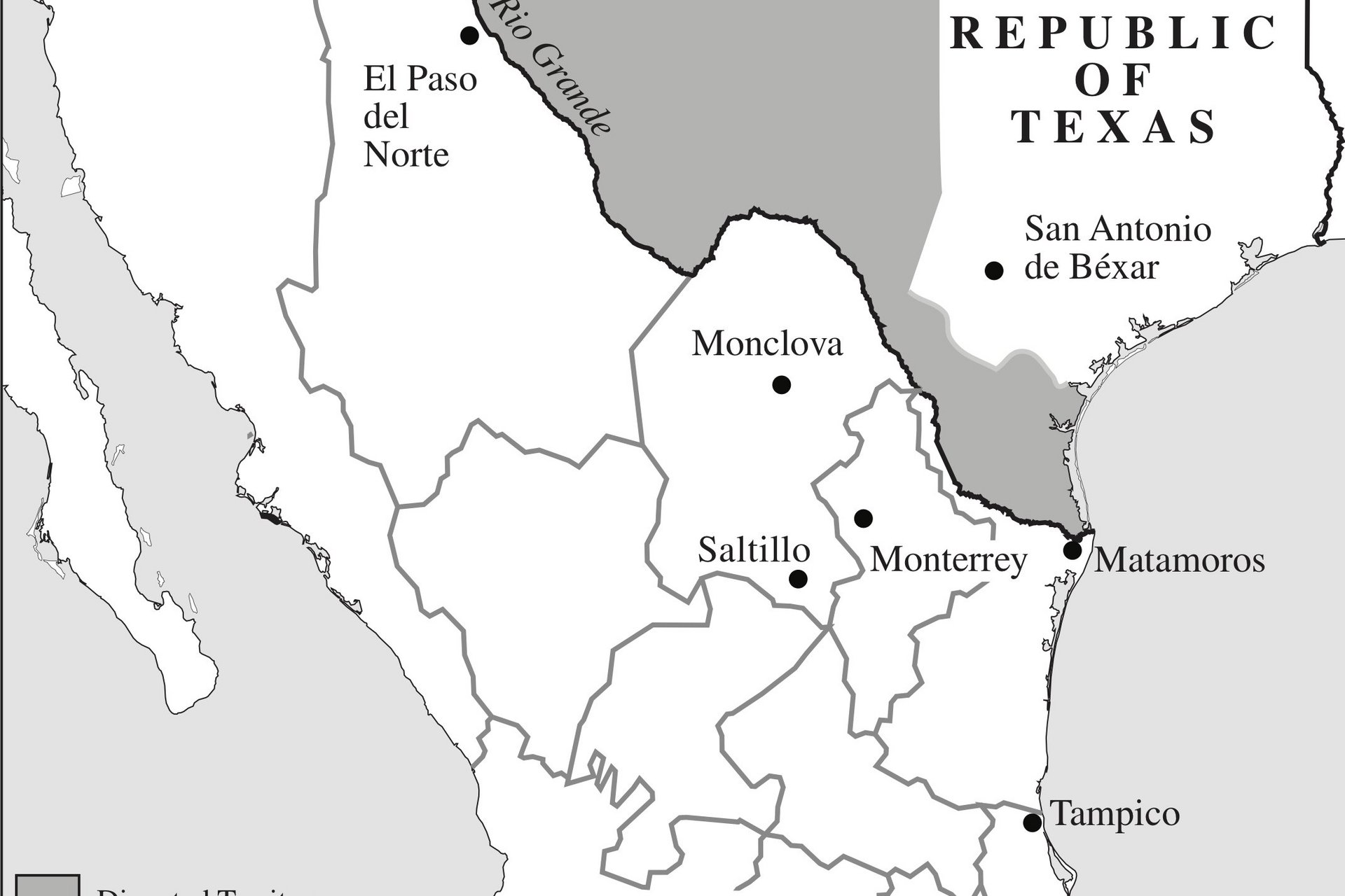
On December 19, 1836, the Congress of the Republic of Texas passed legislation defining the boundaries of its territory. The law stated: <i>That from the passage of this act, the civil and political jurisdiction of the republic be, and hereby declared to extend to the following boundaries, to wit:
beginning at the mouth of the Sabine river, and running west along the Gulf of Mexico three leagues from land, to the mouth of the Rio Grande, thence up the principal stream of said river to its source, thence due north to the forty-second degree of north latitude, thence along the boundary line as defined in the treaty between the United States and Spain, to the beginning: and that the president be, and is hereby authorized and required to open negotiation with the government of the United States of America, as soon as in his opinion the public interest requires it, to ascertain and define the boundary line as agreed to in said treaty.</i> This claim, which stretched the traditional boundary of Texas, guaranteed future conflicts. 

Map No.16: Border Conflicts During the Republic of Texas, 1836-1845

Map of border conflicts in Texas from 1836 to 1845.

Texas Essential Knowledge and Skills

4th Grade TEKS: 4.3C, D & E; 4.6B; 4.8A & B; 4.21B & C; 4.22
7th Grade TEKS: 7.1A; 7.4A & B; 7.8; 7.9; 7.21; 7.22, 7.23    

Map introduction
Sam Houston's victory over Antonio López de Santa Anna did not end the hostilities between Texas and Mexico. Mexico fully intended to reestablish its authority over Texas, as it viewed the region still in revolt and not an independent nation. Internal problems, compounded by a war with France (1838), prevented Mexican officials from giving Texas its full attention. 

Map No.17: Native American Conflicts During the Republic of Texas, 1836-1845

Map of Native American conflicts during the Republic of Texas.

Texas Essential Knowledge and Skills

4th Grade TEKS: 4.3C & D; 4.6B; 4.8A & B; 4.19A, 4.21B & C; 4.22
7th Grade TEKS: 7.1A; 7.4A & C; 7.8; 7.9; 7.19B; 7.21; 7.22, 7.23   

Map introduction
During the period of the Republic, Texas was a battleground as different cultures clashed for control of its resources. Anglo and Tejano citizens of the Republic wanted land for farming and ranching. The native population, historically referred to as Indians, found that encroachment by newer people threatened their traditional way of life. The contest between these groups frequently flared into open conflict. 

Map No.18: The Vote for Annexation, 1845

Map explaining the vote for Texas annexation to the United States in 1845.

Texas Essential Knowledge and Skills

4th Grade TEKS: 4.3C, D & E; 4.6B; 4.8A & B; 4.21B & C; 4.22
7th Grade TEKS: 7.1A; 7.4B; 7.8; 7.9; 7.21; 7.22, 7.23    

Map introduction
One of the continuing questions facing citizens of the Republic of Texas was whether or not to trade its status as an independent nation for a place within the federal union of the United States. President Mirabeau B. Lamar represented the faction strongly opposed to abandoning the
Republic. Lamar's pro-Republic stance, however, did not reflect the attitude of most Texans toward annexation.

Map No.19: Texans in the Mexican War, 1846-1848

Map of Texas in the Mexican War.

Texas Essential Knowledge and Skills

4th Grade TEKS: 4.3D & E; 4.6B; 4.8A & B; 4.21B & C; 4.22
7th Grade TEKS: 7.1A; 7.4C; 7.8; 7.9; 7.21; 7.22, 7.23    

Map introduction
The War with Mexico brought Texans and Mexicans together on the battlefield once more. Their previous conflicts, beginning with the Texas Revolution and continuing throughout the era of the Republic, had created hard feelings on both sides. The new war provided Texans with an opportunity to avenge wrongs and punish old enemies. 

Map No.20: Texas Territory Ceded in the Compromise of 1850

Map of Texas territory ceded in the compromise of 1850.

Texas Essential Knowledge and Skills

4th Grade TEKS: 4.3D & E; 4.6B; 4.8A & B; 4.21B & C; 4.22
7th Grade TEKS: 7.1A; 7.4C; 7.8; 7.9; 7.11A & B; 7.21; 7.22, 7.23     

Map introduction
The Compromise of 1850 is most often associated with three controversial issues of that day: The admission of California to the Union as a free state; the enactment of the Fugitive Slave Law; and the abolition of the slave trade in the District of Columbia. Little remembered about the act is the fact that it created the modern boundaries of the State of Texas.