Mission Gate and Lunette Archaeology - January 30

January 30, 2023

With unit excavations and trenching at the location of the south wall completed in week 8, work shifted to testing investigations in advance of the construction of the Mission Gate and Lunette exhibit. Testing via backhoe trenching and additional monitoring was approved at the Texas Historical Commission Executive Meeting on January 18. Investigations continued throughout the week.

The first trenches to be excavated were those that were within the tree removal zone. In order for the successful removal and relocation of a live oak tree, which currently resides in the project area, tree removal experts will need to excavate a 60 ft x 30 ft x 4 ft trench. To determine if any buried cultural resources will be impacted by the tree work, archaeologists directed the excavation of three backhoe trenches within this zone. Trenches were approximately 15 ft in length, 3 ft in width (with an additional 1 ft bench on either side), and were terminated at hardpan, which ranged from 3.5 to 4.5 ft below surface. Archaeologists followed Council of Texas Archaeologists trenching protocols.

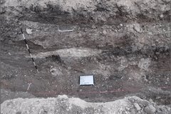
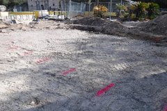
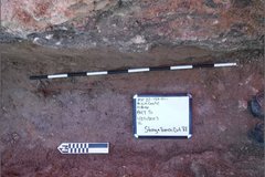
BHT 3 was the eastern most trench in the tree excavation zone (Figure 1). Evidence of previous disturbance, such as an old utility trench, was visible throughout the trench wall profiles. Very few artifacts were recovered. Soils suggest multiple construction episodes or intentionally deposited soils (Figure 2). Hardpan was encountered at approximately 130 cm below surface.

Dirt are with pink line on the left side of Alamo Plaza
Figure 1. Start of excavation for BHT 3, facing north.
Dirt archaeology area with a pink line and a square whiteboard
Figure 2. Soil profile of BHT 3, facing east.

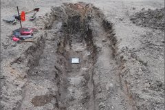
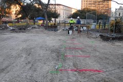
BHT 4 was the middle trench within the tree excavation zone (Figure 3). Methodology was the same as previous trenches. Hardpan was shallower in this trench, approximately 90 cm below surface. The hardpan was also more deteriorated and friable in this area. When the excavator initially encountered the hardpan, because it was so shallow we initially thought it might be a limestone feature. We had the excavator move his bucket to the south of the limestone in an attempt to clean off a side for a better look. This resulted in the excavator actually digging through the hardpan and creating a square cut (Figure 4). The hardpan continued through the entire trench. This trench also had very few artifacts.

Large dirt area to the left of the Alamo with pink lines for marking
Figure 3. Location of BHT 4 with BHT 3 in background, facing northeast.
Long, narrow dug out area of archaeology excavation
Figure 4. BHT 4, with photo board within the excavator-created depression, facing south.

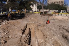
BHT 5 was the western most trench in the trench excavation zone (Figure 5). Initially this trench was placed at the edge of the zone, however upon excavation we realized we were 100% within the 1988/89 excavation area. The entire trench was introduced sand. We moved the trench to the east approximately 1.5 meters. At the new location, BHT 5 still encountered the 1988/89 excavations. A large section of the east wall profile was sand and string leftover from those earlier excavations was left in situ (Figure 6). As in the previous trenches, this trench had very few artifacts and the soils suggest multiple disturbances.

Excavation area next to Alamo Plaza surrounded by fencing
Figure 5. BHT 5, facing north. BHT 4 visible in bottom right corner.
Black and white pole in excavation area next to a marker and a whiteboard
Figure 6. String and sand from 1988 excavations, facing east.

All three backhoe trenches in the tree zone were documented and had Leica points shot it. We also shot in points for the 1988/89 areas that were revealed, since this georeferencing data has never been collected. After we completed the backhoe trenches, we continued to monitor the area as it was graded for the tree removal. No features nor deposits were encountered.

In addition to the three backhoe trenches for tree removal, archaeologists began the trenching in anticipation of the helical pile installation. Methodology was the same as previous trenches, with one modification. With the substantial length of the trench we marked horizontal provenience every 2 meters, instead of 1 meter. We began with the southern trench.

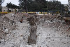
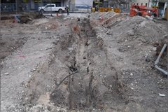
The southern trench is currently still open as we finish the documentation (Figures 7 and 8). This trench is approximately 88 ft in length and 3 ft in width, with an additional 1 ft wide bench on each side. The average depth is approximately 4 ft below surface, with some areas reaching 6 ft. This trench encountered several previous disturbances, including utilities and prior archaeological work. Some artifacts were recovered, such as ferrous metal fragments, glass fragments, and some ceramic sherds. No features were encountered.

Excavation area next to Alamo Plaza with a long, narrow dug out area
Figure 7. BHT 6, southern trench for helical pile testing, facing east.
Excavation area in Alamo Plaza surrounded by fencing across from a white parked truck
Figure 8. BHT 6, southern trench for helical pile testing, facing west.