Mission Gate and Lunette Archaeology - December 9

December 9, 2022

Week 2 started with the completion of the soil removal from the project area. The project area is now approximately level with Alamo Street (Figure 1). There were no cultural materials encountered in the modern soils removed this week.

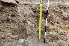
After the project area was at the desired level, archaeologists began the process of locating the 1975 trench which was excavated by UTSA. The location of this trench was significant because within the trench the 1975 UTSA archaeologists encountered a feature that they believed was a remnant of the wall footing of the south mission complex. Using maps generated from the 1975 investigation and archival maps georeferenced on a modern aerial map of Alamo Plaza, the general location of the trench was known. With the assistance of a backhoe, Alamo Trust, Inc. and Raba Kistner archaeologists excavated a small east-west trench to bisect the previously dug trench. The 1975 trench was identified by noting the soil changes (Figure 2).

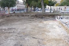
Fenced archaeology project area after the removal of modern soils
Figure 1. Overview of project area after the removal of modern soils.
Yellow tape measure indicating height of excavation unit
Figure 2. Soil change indicating the 1975 trench.

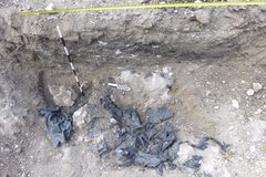
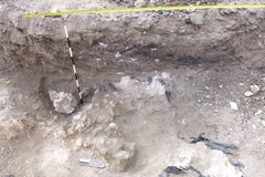
Once the 1975 trench was identified, the backhoe reoriented to excavate in a north-south direction, which was within the 1975 trench. At approximately 115 cm below the surface archaeologists encountered black sheet plastic at the bottom of the trench. Archaeologists often use some type of covering to signal to future excavators that an archaeological feature is located beneath. At this point the backhoe was no longer used and the archaeologists uncovered the plastic by hand (Figure 3). The plastic was removed and beneath was a large mass that closely resembles a geological deposit known as hardpan (Figure 4). This feature is not a portion of a wall.

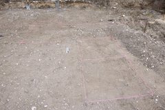
Using the 1975 trench as a reference point, archaeologists placed four 1-m x 1-m excavation units (Figure 5). The location of these units overlaps the south wall depicted in archival maps. Excavation of the units is done by hand in 10 cm levels. This process allows archaeologists to carefully expose any cultural materials. The levels also provide a more precise description of location for any artifacts or cultural features. Thus far, the only cultural materials recovered have been small fragments of metal.

Plastic coverings in the soil in the archaeology project area
Figure 3. Plastic covering a feature encountered in 1975/76.
Pink lines to note excavation units in project area
Figure 5. Excavation units in the project area.
Inside of dirt excavation area
Figure 4. Feature after removal of plastic covering.