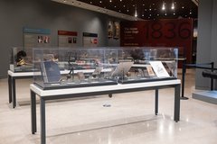
Possible Foundation North of the Long Barrack

Kristi Nichols, Alamo Archaeologist
March 31, 2020

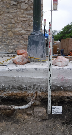
After a backhoe was used to remove layers of road base and some previously disturbed soils for the installation of the safety bollards on the north side of the Plaza, a conduit was revealed coming from one of the traffic lights at the corner of the street. The conduit was encased in concrete. The concrete was removed to allow the engineers to determine more information concerning the location of the conduit and the impact it would have on the positioning of the bollards. Once the concrete was removed, it became apparent that the conduit was in the way of the bollard installation. The concrete removal around the conduit also revealed an exciting feature.

Behind and under a small segment of the conduit, under the currently installed traffic light, a portion of a limestone foundation was revealed in the profile of the trench. Clearing the concrete from the conduit revealed this feature, as it would not have been observed otherwise: the concrete encasing the conduit had obstructed the view of the foundation.

This is an exciting feature because the possible foundation is in line with the west wall of the Long Barrack. Researchers have speculated that another structure, or a continuation of the existing structure, was present north of the Long Barrack. Previous archaeological investigations have not been conducted in alignment with the Long Barrack walls north of the current standing structure.

Long Barrack Foundation
Possible foundation feature encountered under traffic light at Houston Street and Ave E

In addition, the area north of the Long Barrack, in Houston Street, has undergone much impacts by the installation of the myriad of utilities and improvements to the streets, that encountering intact deposits is exciting to allow the archaeologists to better understand the use of the area.

The portion of the foundation revealed only provides a small window. What can be ascertained is that the foundation is constructed of limestone. It is in alignment with the west wall of the Long Barrack, and appears to be running north-south. Any portion of the possible foundation in the rest of the trench had likely been removed during previous utility installations.

It was only observed in the south profile of the safety bollard trench. The width of the foundation is 33 inches, very close to the 33 1/3-inch measurement of a vara. A vara was the unit of measurement used during the Spanish Colonial period in the region, and was used for construction and survey measurements. The measurement of the possible foundation is promising, as it could indicate that the feature is associated with the original construction of the Mission San Antonio de Valero.

The likely significance of the feature resulted in a redesign of the placement of the safety bollards to avoid impacts. Originally, one of the bollards would have been placed in close proximity, providing a very small buffer zone. The engineers worked to shift the spacing of the bollards to provide a sufficient buffer zone to prevent impacts to the feature, while also still protecting the historic structure (Long Barrack) from damage that may be caused from a vehicular impact.

Since the feature is preserved in place, it may provide an opportunity for future investigations to determine the relationship between the feature and the Long Barrack.