Written by Kristi Nichols, Director of Archaeology, Collections, and Historical Research for the Alamo
A Look at the Northeast Corner of the Alamo Gardens
May 5, 2021

As we start examining the feasibility for changes to the Alamo grounds that will allow the staff to better care for the important museum objects, we decided to delve into a study concerning the use of the northeast portion of the property. The northeast corner of the property includes a section of the Alamo Gardens as well as staff parking, and the Alamo Rangers office, in addition to other support buildings such as public restrooms, staff offices, the arbor, and amphitheater (Figure 1). The review of historic maps and photographs can give us insight to the level of change that has occurred on the site since Mission San Antonio de Valero was moved to this area in 1724.
The Alamo Gardens are located beyond the boundary of the original Mission San Antonio de Valero grounds. Initially, the eastern edge of the mission compound consisted of the east wall of the Convento Courtyard, and the east wall of the Church. A portion of the Acequia Madre flowed just outside the compound, providing an additional eastern boundary. An interpretation of the acequia is present on the current Alamo grounds, giving visitors a glimpse at the possible location of the Spanish Colonial irrigation ditch.

The earliest maps of the area were hand-drawn and not to scale but provide very useful information concerning the major improvements and construction activities the Spanish missionaries, presidial soldiers, and early residents of Béxar had undertaken by 1764. Luis Antonio Menchaca, the Captain of the San Antonio de Béxar Presidio, had a map drafted of the town in 1764. The Menchaca Map depicts Mission Valero, the Presidio, the acequia system, as well as San Fernando Church and dwellings. Although there are a few errors in the map depiction, it does show that the area outside of Mission Valero to the east did not contain any structures or roads (Figure 2). This map indicates lands to the east of the mission were undeveloped, although they could have been used for agriculture.

Later depictions of the area indicate it was most likely under or adjacent to a pond at the time of the 1836 Battle and for most of the 19th Century. Maps depicting the area such as the ones drawn by Green B. Jameson, Jean Louis Berlandier (Figure 3), and Ygnacio de Labastida (Figure 4) show the ponding of the acequia east of the Alamo compound in much detail. It would appear from these maps that there were no permanent structures in the area. The area would most likely have been considered not hospitable due to the creation of a swampy environment from ponded acequia waters.


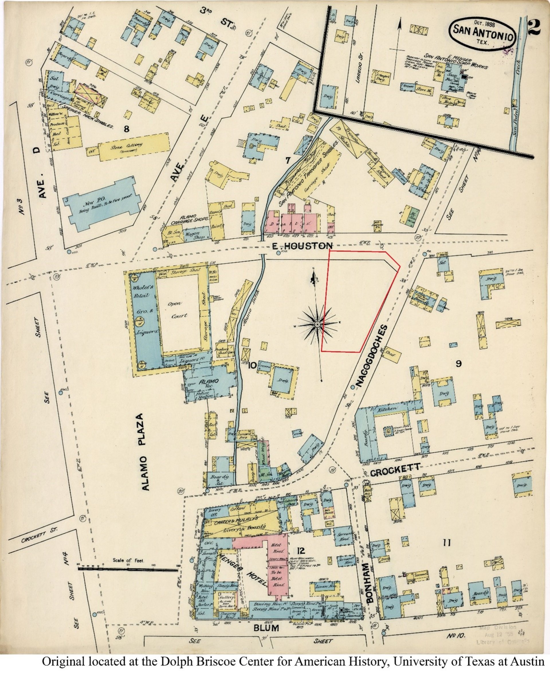
Later in the 19th Century, the area continued to be depicted without structures. The 1873 Bird’s Eye View of San Antonio by Koch shows a grove of trees at the intersection of Nacogdoches (present-day Bonham) and Houston Streets (Figure 5). The early Sanborn Fire Insurance Maps of the area also do not depict structures at the intersection of Houston and Nacogdoches (Bonham) Streets. The 1888 Sanborn Map depicts the area in the vicinity of the northeast portion of the Alamo grounds as vacant (Figure 6).

It was not until the 20th Century that the area was developed. It appears that the development occurred between 1904 and 1912. The 1912 Sanborn map shows several businesses along the Houston Street side of the site: a bowling alley, a tailor and a saloon (Figure 7). Ten years later, the same locations featured the Collins-Clem Studebaker dealership, an auto repair shop, auto livery, and an auto top factory (Figure 8).
Work began on the Long Barrack in 1913, with a low wall of stacked stone construction that fronted Houston Street. This wall appears to have stretched from the northeast corner of the Long Barrack to the first structure to the east (Figure 9). By the 1920s, the section of the current Alamo Garden under investigation exhibited a hotel (Figure 10). A 1931 aerial photo shows most of the site behind the business locations was a parking lot and the auto top factory building at the corner which is no longer standing (Figure 11). The perimeter wall appears to be more substantialy constructed at this time, but again just between the northeast corner of the Long Barrack to the building in the east.


In the 1930s and 1940s, the Alamo garden took shape as the structures came down and the area east of the Alamo was cleared and leveled. A series of sidewalks were installed, and a low wall was erected around the perimeter of the new park. A concrete channel was created to represent the old acequia.
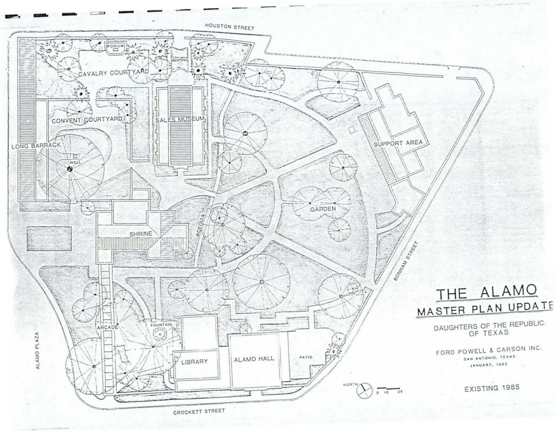
In the 1970s, a few support structures were constructed in the northeastern portion of the Alamo Garden grounds. Figure 12 depicts the location of these structures in 1976, as well as the utilities on the grounds known in 1981. By 1985, a newer support center was constructed (Figure 13) and is still in use today.
In summary, the of the Alamo Gardens are located outside the original boundaries of the Mission San Antonio de Valero compound. A portion of the Acequia Madre (irrigation ditch) flowed just to the east of the compound, and a portion of the Alamo Gardens exist in this area now. It does not appear from the early depictions of the grounds that this area was developed, though it may have been used as an agricultural field during the mission period.
By the time of the Battle of the Alamo, maps depicting the area show that the acequia was ponding to the east of the compound, within the current Alamo Gardens. It is possible that the ponding of the acequia would have created an uninviting location for improvements and was likely left in its original state at that time. Later depictions of the grounds, until 1912, do not indicate any structures were located in the northeastern portion of the current Alamo grounds. The 1912 Sanborn Fire Insurance Map contains the first depictions of any structures. These structures appear to have been present until the 1930s and 1940s, when the Alamo Gardens began to resmble how it appears today. In the 1980s, the grounds were further impacted with the construction of support buildings for the Alamo. In the 1990s, these support buildings were further altered to include the arbor and amphitheater, which are still standing today.