Excavations and documentation associated with the Church and Long Barrack has been completed. The Raba Kistner archaeology team has returned to laboratory to complete analysis and reporting. Archaeological investigations conducted on site this week consisted of archaeological monitoring associated with the installation of safety bollards.
Archaeology Update — Rails From 1800’s Alamo Plaza Street Car System Uncovered

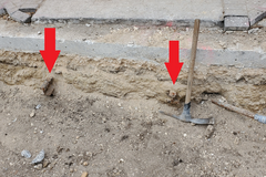
During the monitoring for the safety bollards, two iron rails were uncovered in the north wall of the trench at the north end of the Plaza, adjacent to Houston Street. These rails are smaller gauge than for train cars, therefore indicating that they may be associated with street cars that were active in the area during the late 1800s and early 1900s.
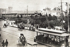
In addition, these are spaced an appropriate distance apart that matches with the street car lines. The use of street cars in San Antonio began in 1878. Until the street cars were electrified in 1890, the first street cars were pulled by horses and mules.
The street car system in San Antonio had a 55-year run, with the use of the line ending in 1933. San Antonio was late to the use of street cars likely because the railroad did not arrive in town until 1877. Other cities that had the railroad system had developed a street car system to help with public transportation and deliver of the goods from the railroad depots.
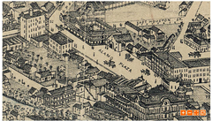
One of the first lines developed connected San Pedro Springs Park to Alamo Plaza. Archival resources indicated that there was a streetcar stop at the Post Office near the Alamo, in the vicinity of the currently standing Federal Building. As addition routes were added, all lines connected to Houston Street.
The street car system resulted in the widening of Houston Street as well as the demise of Commerce Street as the main commercial district. During the late 1880s, the street car routes were expanded to reach outside of downtown to the surrounding suburbs such as Alamo Heights and Woodlawn Park.

At the time the street car system was shut down, the rail lines were either removed or paved over. Most known pictures and maps of the streetcar routes do not place a line this close to the Long Barrack. During the ground penetrating radar survey of 2016, signals consistent with buried street car rails were observed running north and south along the closed portion of Alamo Plaza Street that runs in front of the Long Barrack.
What is seen in the north wall profile, indicates that at least one length of the line was removed at some point, as it doesn’t continue to the south. This may have been due to installations of utilities after 1933. More archival research will need to be done to determine how these rails tie into the overall street car system.


